Housing group GreenSquare has improved efficiency and cut costs by using a geographical information system (GIS).
GreenSquare manages 10,000 homes and has a target of building 30 new homes a year in Wiltshire, Oxfordshire and Gloucestershire. In the past the body relied heavily on physical site visits, and manual methods were used to support its development strategy.

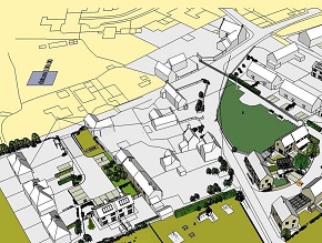
By using software from Esri UK, the body can now overlay various types of geographic information on an interactive map (as shown in the picture) and has been able to reveal several new sites for development and realise new revenue streams. So far, the potential value of this land is approximately 2m.
Feasibility studies for new development sites have been cut to two days from 10, while the property disposal process has been reduced from four days per month to three hours.
The software will also enable the organisation to get a clear picture of which residents will be affected by the government's Welfare Reform Bill in April, which will see a 500 per week household benefit cap placed on welfare recipients – including housing benefits.
Dawn Francis, GIS group manager at GreenSquare, said: "We can switch different types of geographic information on and off on the same map to carry out a forensic analysis and arrive at decisions about the suitability of an area for development, conversion or regeneration. We can see property types, access routes, who owns what land and all the other local factors we need to consider in an initial investigation."
Previously, this was a labour-intensive process, using spreadsheets or disparate sets of maps.


