A deep freeze expected soon in the U.S. Midwest, northeastern New England states and even the South will be one to remember, with potential record-low temperatures heightening fears of frostbite and hypothermia.
It hasn't been this cold for decades—20 years in Washington, D.C., 18 years in Milwaukee, 15 in Missouri—even in the Midwest, where bundling up is second nature. Weather Bell meteorologist Ryan Maue said, "If you're under 40 (years old), you've not seen this stuff before."
Preceded by snow in much of the Midwest, the frigid air will begin Sunday and extend into early next week, funneled as far south as the Gulf Coast. Blame it on a "polar vortex," as one meteorologist calls it, a counterclockwise-rotating pool of cold, dense air.
"It's just a large area of very cold air that comes down, forms over the North Pole or polar regions ... usually stays in Canada, but this time it's going to come all the way into the eastern United States," said National Weather Service meteorologist Phillip Schumacher in Sioux Falls, South Dakota.
The forecasts are startling: 25 below zero Fahrenheit (31 below zero Celsius) in Fargo, North Dakota, minus 31 F (minus 35 C) in International Falls, Minnesota, and 15 below F (26 below C) in Indianapolis and Chicago. At those temperatures, exposed skin can get frostbitten in minutes and hypothermia can quickly set in as wind chills may reach 50, 60 or even 70 below zero F (45.5, 51 or even 56.7 below zero C).
Already, parts of the northeastern New England states dropped into the negatives early Saturday, with East Brighton, Vermont, seeing 30 below zero F (34.4 below zero C) just after midnight and Allagash, Maine, hitting minus 36 F (minus 37.8 C). The cold will sweep through other parts of New England where residents are digging out from a snowstorm.

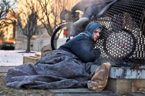
Nick warms himself on a steam grate with three other homeless men by the Federal Trade Commission, just blocks from the Capitol, during frigid temperatures in Washington, Saturday, Jan. 4, 2014. A winter storm that swept across the Midwest this week blew through the Northeast on Friday, leaving bone-chilling cold in its wake. (AP Photo/Jacquelyn Martin)
Snow will reduce the sun's heating effect, so nighttime lows will plummet because of the strong northwest winds, Maue said. Fresh powder is expected in parts of the central Midwest and South starting Saturday night—up to a foot (30 centimeters) in eastern Missouri and southern Michigan, 6 to 8 inches (15 to 20 centimeters) in central Illinois, 8 or more inches (20 or more centimeters) in western Kentucky and up to 6 inches (15 centimeters) in parts of middle Tennessee.
The South also will dip into temperatures rarely seen. By Monday morning, western and central Kentucky could be below zero F (minus 18 C )—"definitely record-breaking," said weather service meteorologist Christine Wielgos in Paducah, Kentucky. And in Atlanta, Tuesday's high is expected to hover in the mid-20s F (around minus 4 Celsius).
.physorg-news-middle-block { width: 550px; height: 90px; } (adsbygoogle = window.adsbygoogle || []).push({});
The arctic chill will affect everything from sports to schools to flights. Mike Duell, with the flight-tracking website FlightAware.com, says to expect airport delays and flight cancellations because of the cold temperatures.
Minnesota has called off school Monday for the entire state—the first such closing in 17 years.
Before the polar plunge, Earth was as close as it gets to the sun each year on Saturday. The planet orbits the sun in an oval and on average is about 93 million miles (149.7 million miles) away. But every January, Earth is at perihelion, and on Saturday, it was only 91.4 million miles (147.1million kilometers) from the sun.
That proximity doesn't affect the planet's temperatures. Maue noted that it's relatively uncommon to have such frigid air blanket so much of the U.S., maybe once a decade or every couple of decades.
At least 16 deaths were blamed on a snow storm that swept across the eastern half of the U.S., including three people who officials said died at least partly because of the extreme cold.
The snowfall had all but stopped by Friday morning in the hard-hit Philadelphia-to-Boston corridor. The cold temperatures kept the snow light and powdery, preventing it from weighing down electrical lines or tree limbs. As a result there were only a few thousand power outages in the Northeast.
However, in Canada, a transformer malfunctioned at the terminal station in Sunnyside, Newfoundland, after an overnight blizzard, knocking out power to 190,000 customers. About 125,000 people remained without electricity Saturday afternoon, mostly in eastern parts of Newfoundland.


